
The US state Kansas (KS) is the 35th largest state by population and 15th biggest state by area. Kansas has 105 counties ranking it the 6th state with the most counties in USA. See below some basic information about the state:
| Country: | United States |
| State: | Kansas |
| Abbreviation: | KS |
| Capital: | Topeka |
| Largest City: | Wichita |
| Population: | 2,913,314 |
| Population rank in US: | 35th |
| Total Area [mi²]: | 82,278 |
| Total Area [km²]: | 213,100 |
| Area rank in US: | 15th |
| Number of Counties: | 105 |
If you want to show data distributon per geographical area, density maps (or heat maps) are a great way to achieve this. For example, here is a Kansas Population Density Map per County:
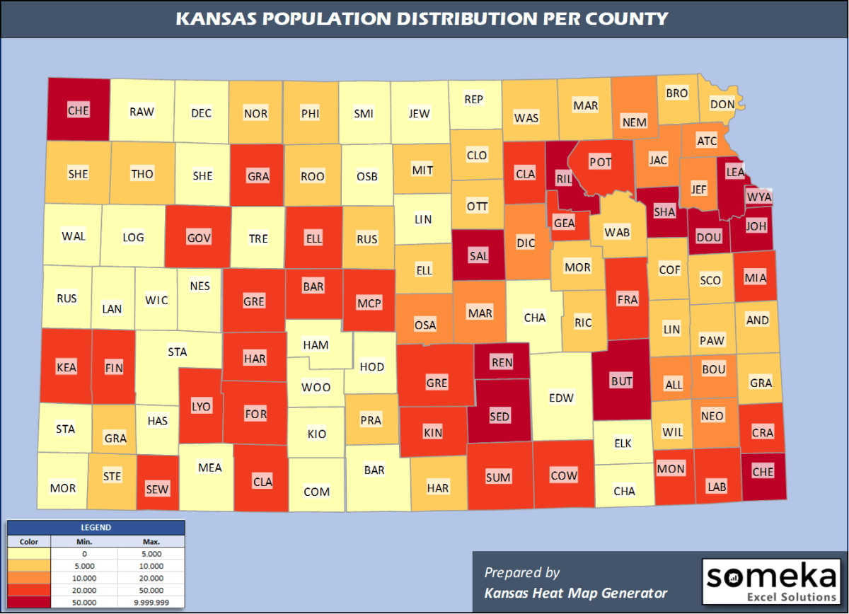
We have prepared this easily with Kansas County Heat Map Generator for population info. But it can also be used for many different data types such as employment rate, average temperature, racial distribution and so on.
Below are 105 Kansas counties ranked by population information. The data is from the US Census Bureau. You can copy and paste this list directly into your spreadsheet.
(Top 10 counties shown. To expand the list, simply click on the “show more” button)
| Rank | County | Population |
|---|---|---|
| 1 | Johnson County | 602,401 |
| 2 | Sedgwick County | 516,042 |
| 3 | Shawnee County | 176,875 |
| 4 | Wyandotte County | 165,429 |
| 5 | Douglas County | 122,259 |
| 6 | Leavenworth County | 81,758 |
| 7 | Riley County | 74,232 |
| 8 | Butler County | 66,911 |
| 9 | Reno County | 61,998 |
| 10 | Saline County | 54,224 |
| 11 | Crawford County | 38,818 |
| 12 | Finney County | 36,467 |
| 13 | Cowley County | 34,908 |
| 14 | Harvey County | 34,429 |
| 15 | Miami County | 34,237 |
| 16 | Ford County | 33,619 |
| 17 | Lyon County | 33,195 |
| 18 | Montgomery County | 31,829 |
| 19 | Geary County | 31,670 |
| 20 | Ellis County | 28,553 |
| 21 | McPherson County | 28,542 |
| 22 | Barton County | 25,779 |
| 23 | Franklin County | 25,544 |
| 24 | Pottawatomie County | 24,383 |
| 25 | Sumner County | 22,836 |
| 26 | Seward County | 21,428 |
| 27 | Cherokee County | 19,939 |
| 28 | Labette County | 19,618 |
| 29 | Jefferson County | 19,043 |
| 30 | Dickinson County | 18,466 |
| 31 | Atchison County | 16,073 |
| 32 | Neosho County | 16,007 |
| 33 | Osage County | 15,949 |
| 34 | Bourbon County | 14,534 |
| 35 | Jackson County | 13,171 |
| 36 | Allen County | 12,369 |
| 37 | Marion County | 11,884 |
| 38 | Nemaha County | 10,231 |
| 39 | Marshall County | 9,707 |
| 40 | Linn County | 9,703 |
| 41 | Brown County | 9,564 |
| 42 | Rice County | 9,537 |
| 43 | Pratt County | 9,164 |
| 44 | Cloud County | 8,786 |
| 45 | Wilson County | 8,525 |
| 46 | Coffey County | 8,179 |
| 47 | Clay County | 8,002 |
| 48 | Anderson County | 7,858 |
| 49 | Thomas County | 7,777 |
| 50 | Doniphan County | 7,600 |
| 51 | Kingman County | 7,152 |
| 52 | Grant County | 7,150 |
| 53 | Wabaunsee County | 6,931 |
| 54 | Russell County | 6,856 |
| 55 | Pawnee County | 6,414 |
| 56 | Ellsworth County | 6,102 |
| 57 | Gray County | 5,988 |
| 58 | Greenwood County | 5,982 |
| 59 | Mitchell County | 5,979 |
| 60 | Sherman County | 5,917 |
| 61 | Ottawa County | 5,704 |
| 62 | Morris County | 5,620 |
| 63 | Stevens County | 5,485 |
| 64 | Harper County | 5,436 |
| 65 | Washington County | 5,406 |
| 66 | Norton County | 5,361 |
| 67 | Phillips County | 5,234 |
| 68 | Rooks County | 4,920 |
| 69 | Scott County | 4,823 |
| 70 | Republic County | 4,636 |
| 71 | Barber County | 4,427 |
| 72 | Stafford County | 4,156 |
| 73 | Meade County | 4,033 |
| 74 | Haskell County | 3,968 |
| 75 | Kearny County | 3,838 |
| 76 | Smith County | 3,583 |
| 77 | Osborne County | 3,421 |
| 78 | Chautauqua County | 3,250 |
| 79 | Woodson County | 3,138 |
| 80 | Rush County | 3,036 |
| 81 | Lincoln County | 2,962 |
| 82 | Jewell County | 2,879 |
| 83 | Decatur County | 2,827 |
| 84 | Trego County | 2,803 |
| 85 | Edwards County | 2,798 |
| 86 | Logan County | 2,794 |
| 87 | Ness County | 2,750 |
| 88 | Cheyenne County | 2,657 |
| 89 | Chase County | 2,648 |
| 90 | Gove County | 2,636 |
| 91 | Morton County | 2,587 |
| 92 | Hamilton County | 2,539 |
| 93 | Rawlins County | 2,530 |
| 94 | Elk County | 2,530 |
| 95 | Sheridan County | 2,521 |
| 96 | Graham County | 2,482 |
| 97 | Kiowa County | 2,475 |
| 98 | Wichita County | 2,119 |
| 99 | Stanton County | 2,006 |
| 100 | Clark County | 1,994 |
| 101 | Hodgeman County | 1,794 |
| 102 | Comanche County | 1,700 |
| 103 | Lane County | 1,535 |
| 104 | Wallace County | 1,518 |
| 105 | Greeley County | 1,232 |
Out of the 105 counties in Kansas, Johnson County is the largest by population. Butler County is the largest by land area.
Greeley County is the smallest Kansas county by population. Wyandotte County is the smallest by size.
In terms of economics and average income level, Johnson County is the richest Kansas county.
Crawford County is the poorest Kansas county.
We have prepared Kansas county density map by population as a downloadable PDF.
You can download the PDF for free from the link below:

Kansas County Density Map PDF
Check the video below to see how we use our Kansas County Map Excel Template to visualize any data over Kansas counties.
We have built the easiest Kansas Heat Map Maker in the universe! It works fully in Excel:
Here is a list of useful links which we think can be helpful whether you work on data visualization or make research about Kansas state and Kansas counties.
Data Source for Population and many other US related data:
https://www.census.gov
Wikipedia Page for List of Kansas Counties:
https://en.wikipedia.org/wiki/List_of_counties_in_Kansas
Official Website of the State of Kansas:
https://governor.kansas.gov/
Are you looking for Kansas Zip Code map?:
Kansas Zip Code Heat Map Generator in Excel

