
The US state Michigan (MI) is the 10th largest state by population and 11th biggest state by area. Michigan has 83 counties ranking it the 15th state with the most counties in USA. See below some basic information about the state:
| Country: | United States |
| State: | Michigan |
| Abbreviation: | MI |
| Capital: | Lansing |
| Largest City: | Detroit |
| Population: | 9,883,635 |
| Population rank in US: | 10th |
| Total Area [mi²]: | 96,716 |
| Total Area [km²]: | 250,493 |
| Area rank in US: | 11th |
| Number of Counties: | 83 |
If you want to show data distributon per geographical area, density maps (or heat maps) are a great way to achieve this. For example, here is a Michigan Population Density Map per County:
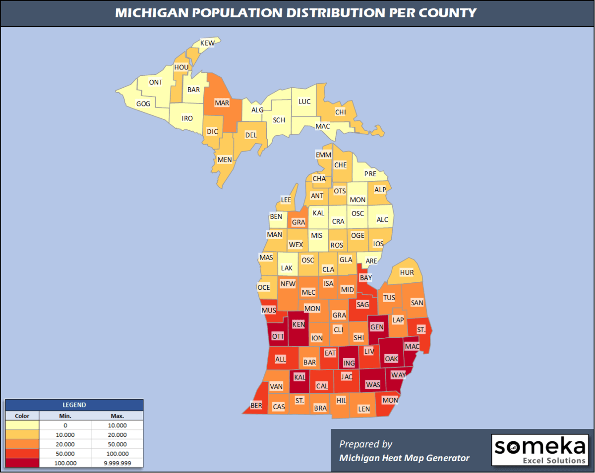
We have prepared this easily with Michigan County Heat Map Generator for population info. But it can also be used for many different data types such as employment rate, average temperature, racial distribution and so on.
Below are 83 Michigan counties ranked by population information. The data is from the US Census Bureau. You can copy and paste this list directly into your spreadsheet.
(Top 10 counties shown. To expand the list, simply click on the “show more” button)
| Rank | County | Population |
|---|---|---|
| 1 | Wayne County | 1,749,343 |
| 2 | Oakland County | 1,257,584 |
| 3 | Macomb County | 873,972 |
| 4 | Kent County | 656,955 |
| 5 | Genesee County | 405,813 |
| 6 | Washtenaw County | 367,601 |
| 7 | Ingham County | 292,406 |
| 8 | Ottawa County | 291,830 |
| 9 | Kalamazoo County | 265,066 |
| 10 | Livingston County | 191,995 |
| 11 | Saginaw County | 190,539 |
| 12 | Muskegon County | 173,566 |
| 13 | St. Clair County | 159,128 |
| 14 | Jackson County | 158,510 |
| 15 | Berrien County | 153,401 |
| 16 | Monroe County | 150,500 |
| 17 | Calhoun County | 134,159 |
| 18 | Allegan County | 118,081 |
| 19 | Eaton County | 110,268 |
| 20 | Bay County | 103,126 |
| 21 | Lenawee County | 98,451 |
| 22 | Grand Traverse County | 93,088 |
| 23 | Lapeer County | 87,607 |
| 24 | Midland County | 83,156 |
| 25 | Clinton County | 79,595 |
| 26 | Van Buren County | 75,677 |
| 27 | Isabella County | 69,872 |
| 28 | Shiawassee County | 68,122 |
| 29 | Marquette County | 66,699 |
| 30 | Ionia County | 64,697 |
| 31 | Montcalm County | 63,888 |
| 32 | Barry County | 61,550 |
| 33 | St. Joseph County | 60,964 |
| 34 | Tuscola County | 52,245 |
| 35 | Cass County | 51,787 |
| 36 | Newaygo County | 48,980 |
| 37 | Hillsdale County | 45,605 |
| 38 | Branch County | 43,517 |
| 39 | Mecosta County | 43,453 |
| 40 | Sanilac County | 41,170 |
| 41 | Gratiot County | 40,711 |
| 42 | Chippewa County | 37,349 |
| 43 | Delta County | 35,784 |
| 44 | Houghton County | 35,684 |
| 45 | Wexford County | 33,631 |
| 46 | Emmet County | 33,415 |
| 47 | Huron County | 30,981 |
| 48 | Clare County | 30,950 |
| 49 | Mason County | 29,144 |
| 50 | Alpena County | 28,405 |
| 51 | Oceana County | 26,467 |
| 52 | Charlevoix County | 26,143 |
| 53 | Gladwin County | 25,449 |
| 54 | Cheboygan County | 25,276 |
| 55 | Dickinson County | 25,239 |
| 56 | Iosco County | 25,127 |
| 57 | Otsego County | 24,668 |
| 58 | Manistee County | 24,558 |
| 59 | Roscommon County | 24,019 |
| 60 | Osceola County | 23,460 |
| 61 | Antrim County | 23,324 |
| 62 | Menominee County | 22,780 |
| 63 | Leelanau County | 21,761 |
| 64 | Ogemaw County | 20,997 |
| 65 | Kalkaska County | 18,038 |
| 66 | Benzie County | 17,766 |
| 67 | Missaukee County | 15,118 |
| 68 | Arenac County | 14,883 |
| 69 | Crawford County | 14,029 |
| 70 | Gogebic County | 13,975 |
| 71 | Presque Isle County | 12,592 |
| 72 | Lake County | 11,853 |
| 73 | Iron County | 11,066 |
| 74 | Mackinac County | 10,799 |
| 75 | Alcona County | 10,405 |
| 76 | Montmorency County | 9,328 |
| 77 | Alger County | 9,108 |
| 78 | Oscoda County | 8,241 |
| 79 | Baraga County | 8,209 |
| 80 | Schoolcraft County | 8,094 |
| 81 | Luce County | 6,229 |
| 82 | Ontonagon County | 5,720 |
| 83 | Keweenaw County | 2,116 |
Out of the 83 counties in Michigan, Wayne County is the largest by population. Marquette County is the largest by land area.
Keweenaw County is the smallest Michigan county by population. Benzie County is the smallest by size.
In terms of economics and average income level, Oakland County is the richest Michigan county.
Lake County is the poorest Michigan county.
We have prepared Michigan county density map by population as a downloadable PDF.
You can download the PDF for free from the link below:

Michigan County Density Map PDF
Check the video below to see how we use our Michigan County Map Excel Template to visualize any data over Michigan counties.
We have built the easiest Michigan Heat Map Maker in the universe! It works fully in Excel:
Here is a list of useful links which we think can be helpful whether you work on data visualization or make research about Michigan state and Michigan counties.
Data Source for Population and many other US related data:
https://www.census.gov
Wikipedia Page for List of Michigan Counties:
https://en.wikipedia.org/wiki/List_of_counties_in_Michigan
Official Website of the State of Michigan:
https://www.michigan.gov/
Are you looking for Michigan Zip Code map?:
Michigan Zip Code Heat Map Generator in Excel

