

The US state Mississippi (MS) is the 34th largest state by population and 32nd biggest state by area. Mississippi has 82 counties ranking it the 16th state with the most counties in USA. See below some basic information about the state:
| Country: | United States |
| State: | Mississippi |
| Abbreviation: | MS |
| Capital: | Jackson |
| Largest City: | Jackson |
| Population: | 2,976,149 |
| Population rank in US: | 34th |
| Total Area [mi²]: | 48,430 |
| Total Area [km²]: | 125,443 |
| Area rank in US: | 32nd |
| Number of Counties: | 82 |
If you want to show data distributon per geographical area, density maps (or heat maps) are a great way to achieve this. For example, here is a Mississippi Population Density Map per County:
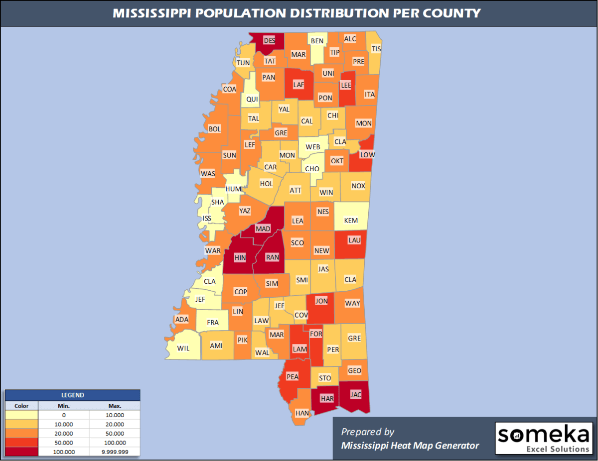
We have prepared this easily with Mississippi County Heat Map Generator for population info. But it can also be used for many different data types such as employment rate, average temperature, racial distribution and so on.
Below are 82 Mississippi counties ranked by population information. The data is from the US Census Bureau. You can copy and paste this list directly into your spreadsheet.
(Top 10 counties shown. To expand the list, simply click on the “show more” button)
| Rank | County | Population |
|---|---|---|
| 1 | Hinds County | 231,840 |
| 2 | Harrison County | 208,080 |
| 3 | DeSoto County | 184,945 |
| 4 | Rankin County | 155,271 |
| 5 | Jackson County | 143,617 |
| 6 | Madison County | 106,272 |
| 7 | Lee County | 85,436 |
| 8 | Forrest County | 74,897 |
| 9 | Lauderdale County | 74,125 |
| 10 | Jones County | 68,098 |
| 11 | Lamar County | 63,343 |
| 12 | Lowndes County | 58,595 |
| 13 | Pearl River County | 55,535 |
| 14 | Lafayette County | 54,019 |
| 15 | Oktibbeha County | 49,587 |
| 16 | Hancock County | 47,632 |
| 17 | Warren County | 45,381 |
| 18 | Washington County | 43,909 |
| 19 | Pike County | 39,288 |
| 20 | Alcorn County | 36,953 |
| 21 | Marshall County | 35,294 |
| 22 | Monroe County | 35,252 |
| 23 | Panola County | 34,192 |
| 24 | Lincoln County | 34,153 |
| 25 | Pontotoc County | 32,174 |
| 26 | Adams County | 30,693 |
| 27 | Bolivar County | 30,628 |
| 28 | Yazoo County | 29,690 |
| 29 | Neshoba County | 29,118 |
| 30 | Union County | 28,815 |
| 31 | Tate County | 28,321 |
| 32 | Leflore County | 28,183 |
| 33 | Scott County | 28,124 |
| 34 | Copiah County | 28,065 |
| 35 | Simpson County | 26,658 |
| 36 | Prentiss County | 25,126 |
| 37 | Sunflower County | 25,110 |
| 38 | Marion County | 24,573 |
| 39 | George County | 24,500 |
| 40 | Itawamba County | 23,390 |
| 41 | Leake County | 22,786 |
| 42 | Coahoma County | 22,124 |
| 43 | Tippah County | 22,015 |
| 44 | Newton County | 21,018 |
| 45 | Grenada County | 20,758 |
| 46 | Wayne County | 20,183 |
| 47 | Tishomingo County | 19,383 |
| 48 | Clay County | 19,316 |
| 49 | Covington County | 18,636 |
| 50 | Stone County | 18,336 |
| 51 | Attala County | 18,174 |
| 52 | Winston County | 17,955 |
| 53 | Chickasaw County | 17,103 |
| 54 | Holmes County | 17,010 |
| 55 | Jasper County | 16,383 |
| 56 | Smith County | 15,916 |
| 57 | Clarke County | 15,541 |
| 58 | Calhoun County | 14,361 |
| 59 | Walthall County | 14,286 |
| 60 | Tallahatchie County | 13,809 |
| 61 | Greene County | 13,586 |
| 62 | Lawrence County | 12,586 |
| 63 | Amite County | 12,297 |
| 64 | Yalobusha County | 12,108 |
| 65 | Perry County | 11,973 |
| 66 | Jefferson Davis County | 11,128 |
| 67 | Noxubee County | 10,417 |
| 68 | Carroll County | 9,947 |
| 69 | Montgomery County | 9,775 |
| 70 | Kemper County | 9,742 |
| 71 | Webster County | 9,689 |
| 72 | Tunica County | 9,632 |
| 73 | Claiborne County | 8,988 |
| 74 | Wilkinson County | 8,630 |
| 75 | Benton County | 8,259 |
| 76 | Choctaw County | 8,210 |
| 77 | Humphreys County | 8,064 |
| 78 | Franklin County | 7,713 |
| 79 | Jefferson County | 6,990 |
| 80 | Quitman County | 6,792 |
| 81 | Sharkey County | 4,321 |
| 82 | Issaquena County | 1,327 |
Out of the 82 counties in Mississippi, Hinds County is the largest by population. Yazoo County is the largest by land area.
Issaquena County is the smallest Mississippi county by population. Alcorn County is the smallest by size.
In terms of economics and average income level, Madison County is the richest Mississippi county.
Issaquena County is the poorest Mississippi county.
We have prepared Mississippi county density map by population as a downloadable PDF.
You can download the PDF for free from the link below:

Mississippi County Density Map PDF
Check the video below to see how we use our Mississippi County Map Excel Template to visualize any data over Mississippi counties.
We have built the easiest Mississippi Heat Map Maker in the universe! It works fully in Excel:
Here is a list of useful links which we think can be helpful whether you work on data visualization or make research about Mississippi state and Mississippi counties.
Data Source for Population and many other US related data:
https://www.census.gov
Wikipedia Page for List of Mississippi Counties:
https://en.wikipedia.org/wiki/List_of_counties_in_Mississippi
Official Website of the State of Mississippi:
https://www.ms.gov/home
Are you looking for Mississippi Zip Code map?:
Mississippi Zip Code Heat Map Generator in Excel

