
The US state Pennsylvania (PA) is the 5th largest state by population and 33rd biggest state by area. Pennsylvania has 67 counties ranking it the 20th state with the most counties in USA. See below some basic information about the state:
| Country: | United States |
| State: | Pennsylvania |
| Abbreviation: | PA |
| Capital: | Harrisburg |
| Largest City: | Philadelphia |
| Population: | 12,801,989 |
| Population rank in US: | 5th |
| Total Area [mi²]: | 46,055 |
| Total Area [km²]: | 119,283 |
| Area rank in US: | 33rd |
| Number of Counties: | 67 |
If you want to show data distributon per geographical area, density maps (or heat maps) are a great way to achieve this. For example, here is a Pennsylvania Population Density Map per County:
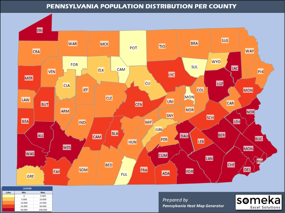
We have prepared this easily with Pennsylvania County Heat Map Generator for population info. But it can also be used for many different data types such as employment rate, average temperature, racial distribution and so on.
Below are 67 Pennsylvania counties ranked by population information. The data is from the US Census Bureau. You can copy and paste this list directly into your spreadsheet.
(Top 10 counties shown. To expand the list, simply click on the “show more” button)
| Rank | County | Population |
|---|---|---|
| 1 | Philadelphia County | 1,584,064 |
| 2 | Allegheny County | 1,216,045 |
| 3 | Montgomery County | 830,915 |
| 4 | Bucks County | 628,270 |
| 5 | Delaware County | 566,747 |
| 6 | Lancaster County | 545,724 |
| 7 | Chester County | 524,989 |
| 8 | York County | 449,058 |
| 9 | Berks County | 421,164 |
| 10 | Lehigh County | 369,318 |
| 11 | Westmoreland County | 348,899 |
| 12 | Luzerne County | 317,417 |
| 13 | Northampton County | 305,285 |
| 14 | Dauphin County | 278,299 |
| 15 | Erie County | 269,728 |
| 16 | Cumberland County | 253,370 |
| 17 | Lackawanna County | 209,674 |
| 18 | Washington County | 206,865 |
| 19 | Butler County | 187,853 |
| 20 | Monroe County | 170,271 |
| 21 | Beaver County | 163,929 |
| 22 | Centre County | 162,385 |
| 23 | Franklin County | 155,027 |
| 24 | Lebanon County | 141,793 |
| 25 | Schuylkill County | 141,359 |
| 26 | Cambria County | 130,192 |
| 27 | Fayette County | 129,274 |
| 28 | Blair County | 121,829 |
| 29 | Lycoming County | 113,299 |
| 30 | Mercer County | 109,424 |
| 31 | Adams County | 103,009 |
| 32 | Northumberland County | 90,843 |
| 33 | Lawrence County | 85,512 |
| 34 | Crawford County | 84,629 |
| 35 | Indiana County | 84,073 |
| 36 | Clearfield County | 79,255 |
| 37 | Somerset County | 73,447 |
| 38 | Columbia County | 64,964 |
| 39 | Armstrong County | 64,735 |
| 40 | Carbon County | 64,182 |
| 41 | Bradford County | 60,323 |
| 42 | Pike County | 55,809 |
| 43 | Wayne County | 51,361 |
| 44 | Venango County | 50,668 |
| 45 | Bedford County | 47,888 |
| 46 | Perry County | 46,272 |
| 47 | Mifflin County | 46,138 |
| 48 | Huntingdon County | 45,144 |
| 49 | Union County | 44,923 |
| 50 | Jefferson County | 43,425 |
| 51 | McKean County | 40,625 |
| 52 | Tioga County | 40,591 |
| 53 | Snyder County | 40,372 |
| 54 | Susquehanna County | 40,328 |
| 55 | Warren County | 39,191 |
| 56 | Clinton County | 38,632 |
| 57 | Clarion County | 38,438 |
| 58 | Greene County | 36,233 |
| 59 | Elk County | 29,910 |
| 60 | Wyoming County | 26,794 |
| 61 | Juniata County | 24,763 |
| 62 | Montour County | 18,230 |
| 63 | Potter County | 16,526 |
| 64 | Fulton County | 14,530 |
| 65 | Forest County | 7,247 |
| 66 | Sullivan County | 6,066 |
| 67 | Cameron County | 4,447 |
Out of the 67 counties in Pennsylvania, Philadelphia County is the largest by population. Lycoming County is the largest by land area.
Cameron County is the smallest Pennsylvania county by population. Montour County is the smallest by size.
In terms of economics and average income level, Chester County is the richest Pennsylvania county.
Forest County is the poorest Pennsylvania county.
We have prepared Pennsylvania county density map by population as a downloadable PDF.
You can download the PDF for free from the link below:

Pennsylvania County Density Map PDF
Check the video below to see how we use our Pennsylvania County Map Excel Template to visualize any data over Pennsylvania counties.
We have built the easiest Pennsylvania Heat Map Maker in the universe! It works fully in Excel:
Here is a list of useful links which we think can be helpful whether you work on data visualization or make research about Pennsylvania state and Pennsylvania counties.
Data Source for Population and many other US related data:
https://www.census.gov
Wikipedia Page for List of Pennsylvania Counties:
https://en.wikipedia.org/wiki/List_of_counties_in_Pennsylvania
Official Website of the State of Pennsylvania:
https://www.pa.gov
Are you looking for Pennsylvania Zip Code map?:
Pennsylvania Zip Code Heat Map Generator in Excel

